

Printable maps of Bukhara


Interactive maps of hiking and biking routes around Bukhara
1. You can zoom in/out using your mouse wheel, as well as move the map of Bukhara with your mouse.2. This interactive map presents two modes: 'Biking Routes' and 'Hiking Routes'. Use the '+' button on the map to switch between them.
Railway and landscape maps of Bukhara area
This Bukhara map has two modes: 'Railway Network' and 'Landscape & Rural Map'. Use the '+' button on the map to navigate.City tours, excursions and tickets in Bukhara and surroundings
Nature and parks of Uzbekistan
Uzbekistan occupies vast expanses in the heart of Central Asia, the interfluves of the Amu Darya and the Syr Darya. The natural diversity of the country has Plains and Mountain landscapes organically combined. Plains are represented by the ancient Ustyurt plateau, river deltas and the Kyzylkum Desert. Mountain relief is formed by the mountains of Tien-Shan and Gissar-Alai. The unique nature of the region unites Lakes and Waterfalls, Canyons and Mountain Peaks, Steppes and Deserts, Nature Reserves and National Parks. Uzbekistan has a sharply continental climate with dry summers and cold, frosty winters. The picturesque and many-sided nature of this sunny country is open to tourists in its entire splendor, offering various attractions for visit. … OpenPhotogallery of Bukhara sights


Our guide to Bukhara
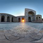
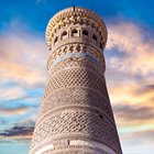
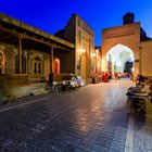
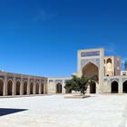
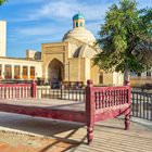
Bukhara sightseeing
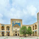
When exploring Bukhara, visit the palace built to honor the last emir of the city - Mir Mohammed Alim Khan. This residence was built at the end of the 19th century. Inside the palace, visitors can see artworks created by local talents. These crafts are exhibited in the Art Museum that is open in the palace. Nowadays, this architectural landmark is a UNESCO World Heritage Site. If we translate the name of the … Open 